


Untangling San Diego’s Zoning Complexity: How Zoneomics is Simplifying Land Use for Developers
Zoning information serves as the regulatory framework for land use in cities, providing shape to everything from residential developments to commercial spaces and green spaces. Typically, zoning is structured into a hierarchy of districts or zones, each further defined with specific permitted uses and Building Controls. All of this zoning information is outlined in zoning ordinances and zoning codes, which act as legal reference documents that guide how land can be used in a particular area. Cities are often divided into residential, commercial, industrial, or mixed-use zones, each of which has regulations about the kind of structures that can be built and how the land can be used.
At the center of zoning information are 2 key components: Permitted Land Uses and Building Controls (also known as Development Standards). Land Use classifications codify the types of activities or developments allowed in each zone and on each property. For example, residential zones may allow single-family or multi-family buildings but restrict commercial activities on the property. Vice versa, commercial zones would permit retail buildings or offices while prohibiting residential activities. Land Use classifications offer a broad overview of the land-use intent for each area within a city.
Building Controls/Development Standards provide granular control over how structures can be built in each zone. Controls typically cover dimensions such as building height limits, setbacks, lot area, lot coverage, floor area ratios, and other similar requirements. These are meant to control the scale and impact of development, ensuring that new structures can fit within the character of its neighborhood. Together, Permitted Land Use classifications and Building Controls are the foundational elements of zoning information.
Zoning is commonly outlined in a comprehensive Zoning Code containing all the pertinent details including Building Controls and Permitted Land Uses. However, in practice zoning is rarely straightforward. Since it is designed and decided at the city level, zoning practices differ greatly between cities. Even within cities, Building Controls and Land Use can often require cross-referencing multiple layers of documents, including overlay zones, design guidelines, environmental considerations, and more. This happens in some cities far more than others and makes interpreting zoning information more complex, as developers, investors, planners, and property owners must navigate a labyrinth of rules and exceptions, often requiring professional expertise to ensure compliance. The element of conditionality adds even deeper layers of intricacy. While a Zoning Code would typically provide one set of Building Controls for each zone, in some cases, Building Controls can vary within a zone based on certain conditions or uses, e.g. for Single-Family Dwellings, the Maximum Allowed Height would be 30 ft but for Multi-Family units it would be 75 ft or that the Setback for a corner lot will be 15 ft and for all other lots it will be 10 ft. All of this variability underscores the importance of having access to clear, comprehensive, and consolidated zoning data and tools that can simplify the process and ultimately enable stakeholders to make informed decisions with certainty.
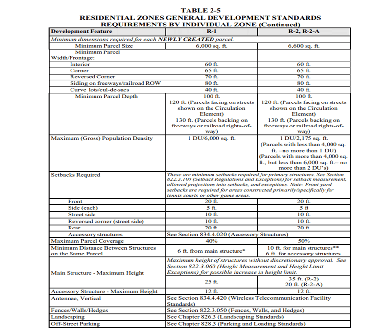
How zoning data is normally available in ordinances.
How San Diego’s Zoning is structured
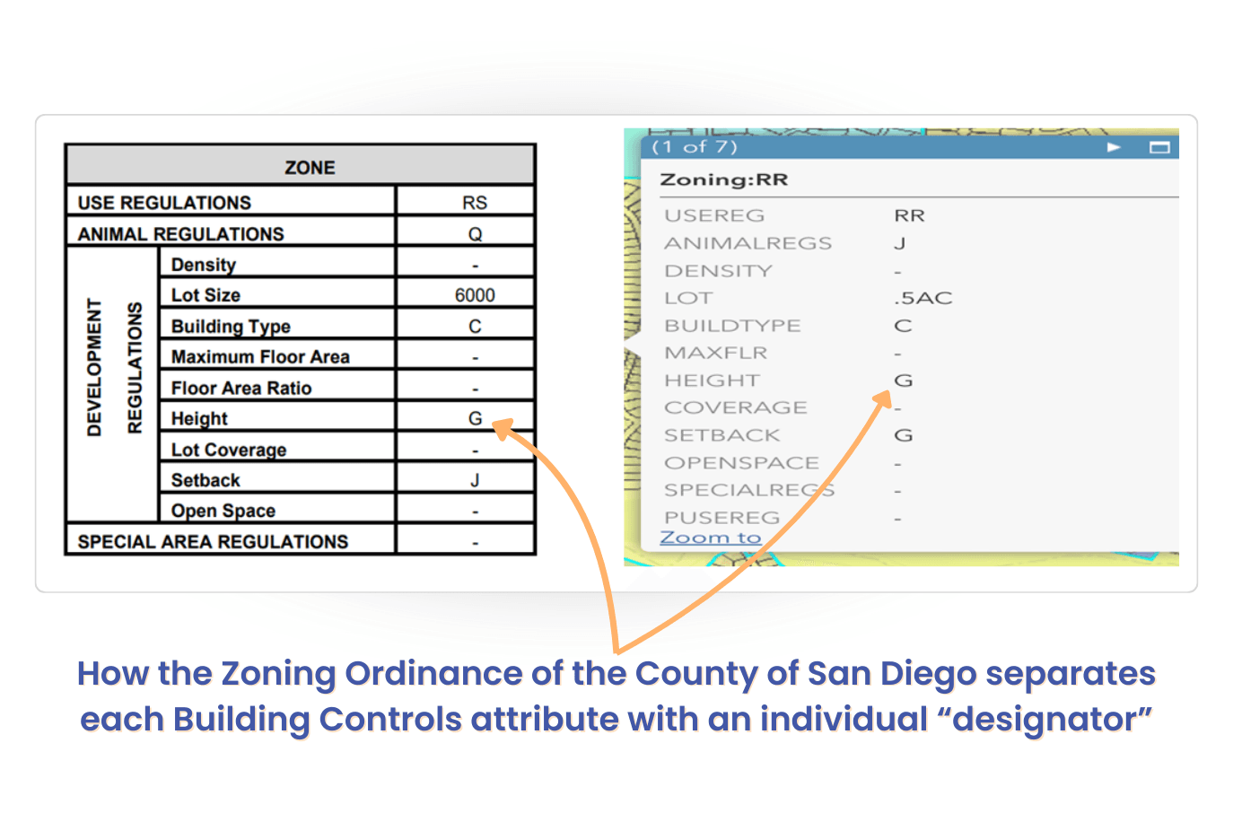
San Diego County ordinance is structured in a very different way than most others. Most zoning ordinances utilize a zoning system that specifies Permitted Land Uses and Building Controls such as Lot Size, Density, Height, Building Types, and other requirements. In San Diego, the county Zoning Ordinance separates or removes these subjects and governs each with individual “designators” e.g. a zone RR with a designator “G”. This seemingly simple label requires us to dig deeper, cross-referencing with additional documents to decode its meaning. Adding to the complexity, "G" can signify different requirements depending on the context—what it dictates for one type of residential property could vary significantly from another residential or commercial property. This nuanced system demands a meticulous approach to understand and navigate the city’s zoning landscape fully.
In practice, this means that when you check zoning for a property, you can’t simply read out the code and are instead compelled to cross-reference the designator information with additional documents to get the exact Controls and Permitted Land Use values to be considered.
In short, this means that conducting any sort of detailed prospecting search, advanced analysis, and gathering zoning data insight in San Diego is exceptionally challenging.
How Zoneomics has tackled the complexities of San Diego’s Zoning Structure
The Zoneomics team takes a multi-faceted approach to simplifying the complexities of San Diego’s zoning structure. By standardizing zoning data fields and organizing information on Permitted Land Uses and Controls for automated cross-referencing, we deliver comprehensive Zoning Data Solutions tailored for San Diego.
The Zoning Data team at Zoneomics combines all the columns in the Zone Code to better understand the controls, with quick information without going into the details of each data cell.
Here is an example of the code prepared by us:
C30-AR(A)-D(-)-LOT(1000)-BT(X)-MFAR(-)-FAR(1.00)-H(G)-COV(0.75)-SB(A)-OS(P)-SR(D)
C30 = Base Zone i.e Commercial as in source columns
AR = Animal Regulations
D = Density
LOT = Lot Area
BT = Building Type
MFAR = Max Floor Area Ratio
FAR = Floor Area Ratio
H = Height
COV = Coverage
SB = Setbacks
OS = Open Space
SR = Special Regulations
The real twist with rationalizing the data in San Diego comes with additional values, like AR(A), H(G), SB(V), SR(D). The values of LOT, D, MFAR, FAR, COV are directly taken from the source. For others like AR, BT, H, SB, OS, and SR, we will need to consult the designator tables available in the ordinance.
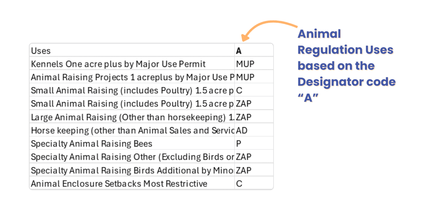
AR Designator table: C30- AR(A)
In the case of code “A”, the following are the uses which will be added as Permitted Land Uses.
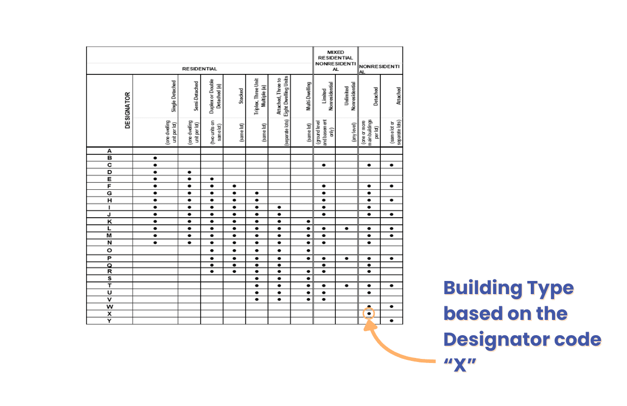
BT Designator table: BT(X)
In the case of code “ X”, it is Non-Residential Detached (one or more main buildings per lot)
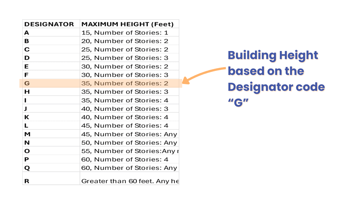
H Designator table: H(G)
Based on the code “G”, the maximum height for G should be 35 ft and 2 Stories.
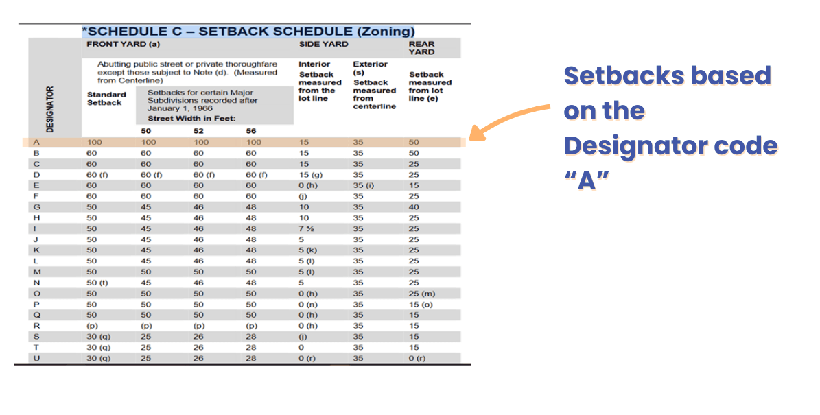
SB Designator table: SB(A)
Based on the code “A”, the Setbacks for A are as follows:
- Front Yard = 100ft
- Side Yard = lot line: 15ft, exterior: 35ft
- Rear Yard = 50ft
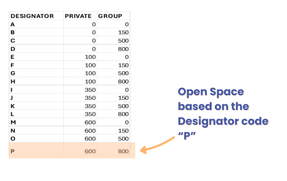
OS Designator table: OS(P)
Based on the code “P”, the value for Open space = Usable Open Space Per Dwelling Unit (Square feet) : (Private: 600, Group: 500)
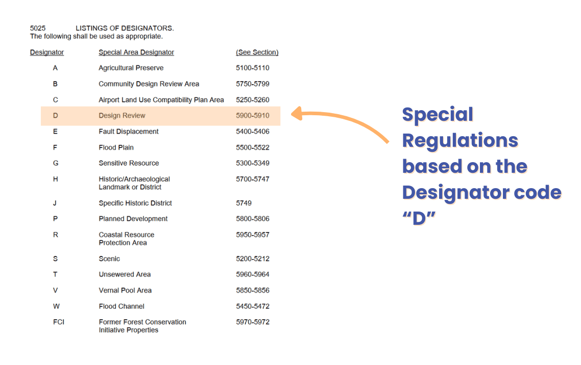
SR Designator table: SR(D)
For Special Regulations, it's important to refer to the section mentioned against each Designator in its table.
Based on the code ”D”, “Design Review” from sections 5900-5910 would be referred to.
How to access Zoning information for San Diego on Zoneomics
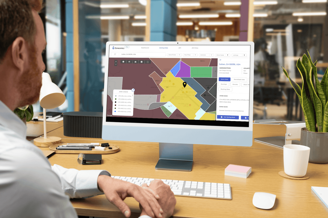
To access zoning information for a property on Zoneomics, you can search for addresses in San Diego on the zoneomics Web App, or visit the city page for San Diego and San Diego Unincorporated and then enter an address. From there you can find all the relevant information about the property including its Zoning, Permitted Land Uses, Building Controls, Overlays, Parcels, Parking Data, and Short Term Rental information. Users can download Zoning Brief reports, export the data as a CSV file, or order detailed Zoning Report Products. Data is also accessible via API. Visit this page on the website to learn more about our API offerings.